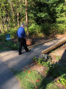
David Korten enters the John Nelson Trail from the STO. Photo credit: Fran Korten
By Fran Korten
It took just a few feet of boardwalk but a pile of permissions to make the John Nelson Trail became readily accessible to the public.
It used to be that you could only find the entrance to the Trail by hiking up the Vineyard Lane hill on the east side of SR 305. Now you can just walk across a boardwalk from the well-trafficked Winslow Connector of the Sound to Olympics Trail (STO) that goes from Winslow Way to High School Road.
Walk across the boardwalk, located on the STO just north of the entrance to Vineyard Lane, and suddenly you are in the midst of a forest. The Trail is just a third of a mile. But what makes it special are the dramatic views you see as you skirt the deep upper Winslow Ravine, where treetops are at trail level.
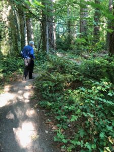
A forest in the heart of Bainbridge. Photo credit: Fran Korten
This new STO connection is emblematic of the long-term vision that trail advocates Don Willott and Dave Shorett, among others, have for the STO. They see that the STO can serve not only as a protected corridor and greenway from the Bainbridge ferry eventually all the way to the Hood Canal Bridge, but also as a spine that connects with many other trails.
What it took to connect the Nelson Trail to the STO
So what was that pile of permissions needed to make this small connection work? Dave Shorett told me the story. To install a trail connection from the STO requires permission from the Washington State Department of Transportation. Plus you need agreements from the City of Bainbridge Island and the Bainbridge Island Parks District. Shorett noted that none of these permissions was difficult to get. But coordinating three independent bureaucracies takes more work than most busy public servants can muster. So Shorett provided the coordination, obtaining the relevant form from WSDOT, getting it signed by Dan Hamlin at Parks, approved by Mark Epstein at the City, and working with the “curb cut guy” at WSDOT. Together, they all made it work.
How did we get the John Nelson Trail?
The story of this trail and the land it traverses is a complicated one, as Shorett explained. John Nelson owned a 5-acre tract of land near what is now Vineyard Lane. When he died in 1949, he deeded the land to the city in his will, specifying it was to made into a park. But the project languished. In the meantime Bill Carruthers, developer of Vineyard Lane, had his eye on that parcel to expand his development. At the same time, a number of park enthusiasts were eager to turn the cove where the strawberry plant was once located into a public park. That spot could give kayakers, paddleboarders, and swimmers ready access to Eagle Harbor.
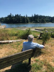
John Nelson Park at Strawberry Cannery Cove. Photo credit: Fran Korten
Carruthers volunteered to buy the strawberry plant parcel and give it to the Parks District if he could get the Nelson Park property in exchange. The exchange was not without controversy. But in 2004 the swap was made on the condition that one acre be kept for park use, subsequently for a trail. So now, because of the swap, John Nelson is remembered in two places—the John Nelson Trail on his original property and also the John Nelson Park at Strawberry Cannery Cove. And the public benefits from two lovely, accessible parks.