
I think this watershed might win a prize for the watershed that is sort of not much of a watershed…. If that’s a thing. We’re talking this month about the South Beach watershed, which extends along the south side of Restoration Point, pictured below, northward to Fort Ward. One of the striking things about this watershed is how few streams it contains. The reason for this goes back to a major geologic event about 1100 years ago, when an earthquake on the crustal Seattle fault caused most of the area around Blakely Harbor and Fort Ward south to Restoration Point, at the south end of Bainbridge Island, to instantaneously uplift about 7 meters. This uplift turned Restoration Point from what used to be an Island into a connected part of the south end of Bainbridge, and uplifted marine terraces which can be seen along the shoreline from the Point north to Fort Ward Park (check out this cool water trail history of the area for some great photos and more info on this geologic history).
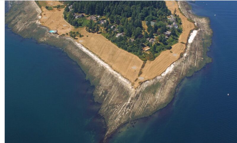
Restoration Point, Bainbridge Island. Photo by USGS.
If you look at the shoreline in this photo, taken by the USGS at low tide, you can see the bedrock marine terraces left at the surface during this uplift event. Bedrock is a tightly grained parent material, and it does not easily host the types of seeps and springs that we can find throughout much of the rest of Bainbridge Island. The presence of this bedrock means several things for this watershed- few, seasonal streams, and also, related to this, minimal water storage capacity, aka aquifers, in this area of the Island. You won’t find streams that can support many fish in this part of the Island- but you will find a fascinating intertidal habitat with a unique assemblage of marine life that thrives on hard surfaces. I encourage you to check out our colleagues over at Bainbridge Beach Naturalists next time they do a shoreline walk at Fort Ward or nearby spots to check out the creatures that can be seen among these marine terrace formations.